What a beautiful morning! A perfect blue sky overhead. Perhaps a day for Bidean a' Choire Sheasgaidh and Lurg Mhor? Maybe not! After yesterday's mega-walk, I had a slight tweak in one knee, so decided that my tired muscles needed a rest ...
 |
| The Cuillin above the Skye Bridge, seen from Balmacara |
However, at Broadford, on impulse, I turned left along the Elgol road, passing Kilbride farm, where Anne and I had honeymooned in a log cabin 30 years earlier. Through Torrin, and down to the shore of Loch Slapin - and there stood Bla Bheinn (Blaven) in all its splendour. Cue a stop by the shore and many photos ...
 |
| Bla Bheinn an Clach Glas above Loch Slapin on a perfect morning |
We had been here 29 years ago, to watch the sun set over the Cuillin on a beautiful July evening ... and experienced a horrible sinking feeling as I wound the camera film forward (as you did in those days!) past 36, then 37, then 38 .... and realised that I had taken a whole film of 36 photos without the film having been properly loaded! So no pictures of the climb of Bla Bheinn, or of the sunset from Elgol ... :-(
Now was time to make amends ...
Just one of many pictures I took from Elgol this beautiful morning:
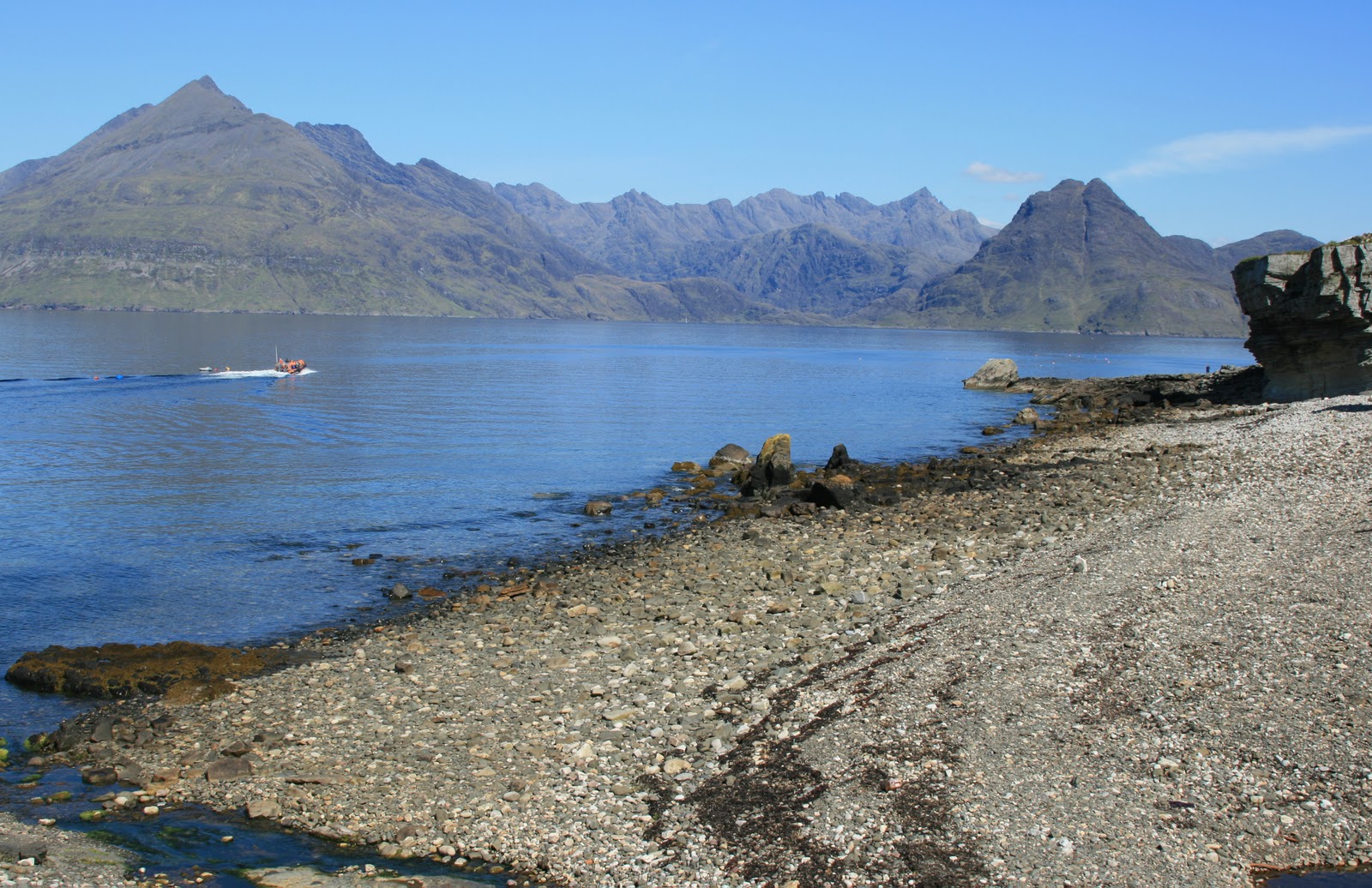 |
| The Cuillin from Elgol |
Five minutes up the track, I heard a car alarm go off back at the car park. Was it mine? Hesitation... Probably not, so I carried on walking a bit. Then I heard it again, and doubt crept in - better go back and check. So, back down the track! Sure enough, it was mine! Just as well I had returned! Sorted the problem, then set off once again! This time, I was able to continue, and soon was at the top and looking down on Camas Fhionnairigh (Camusunary), with superb views of the hills behind.
 |
| Camasunary Bay, with Sgurr na Stri and the Cuillins behind |
 |
| Anne on the Camasunary bridge in 1980 |
I followed the good path round the point, below Sgurr na Stri, with the waters of Loch Scavaig a deep blue, and the mountains towering ever higher as I got nearer.
 |
| on the path round towards Loch Coruisk |
 |
| David on the "bad step", 1980 |
We had managed it fine back in 1980 (left), so surely "no worries!"
Soon I was approaching it, and could see a family making the "crossing". I was surprised to see that it wasn't really as I had remembered it. It definitely looked a bit trickier! I manoeuvred carefully round under the "cave", and peered round to where the family were coming down the "crack" one by one, the Dad helping each one down to safety (below).
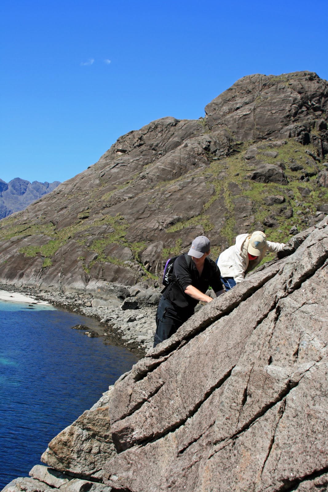
Suddenly, I had cold feet! I didn't like the look of it at all!
What if i managed to get "up" (with help around), but couldn't get back down on my own later?
I retreated, and found a good place from which to sit and watch, about 100m back. A cup of coffee should steady the nerves!
"This is ridiculous", I said to myself. "Tomorrow you are going on to the Cuillin Ridge with Winky O'Neale, and you're going to have to admit you bottled out on the 'so-called bad step'! You're going to have to do it!"
 |
| the "bad step", family in the "cave" below the "bad step" |
Very gingerly (as there was no-one around to fish me out of the sea 20m below if I fell) I eased myself up out of the "cave" and astride the crack, then pulled myself upright and got a good fingertip hold on the upper crack, then shuffled my way up. Two minutes later, I had succeeded! Whew, what was all the fuss about?!
Once the heartbeat had returned to normal, I continued round the shore, then up the rock slabs for a view up Loch Coruisk (below). No-one else in sight. What a dramatic spot!
 |
| Loch Coruisk |
So, about turn back to the top of Loch Scavaig. How would the "bad step" feel in reverse, I wondered? I suddenly remembered that I had never done it in this direction. 30 years earlier, we had decided to return to Camasunary over the ridge of Sgurr na Stri. I wonder why??!
 |
| The "Bad Step" from the Loch Coruisk end - the route is along the slanting crack across the slab |
Now it was time to head back round the point to Camasunary, where I caught up with the family I had been watching earlier on "the step". We exchanged e-mail addresses, so that I could send them the photos I had taken of them.
PS "If you (the Staley family described above) are reading this, did you ever receive the pictures? I sent them to the e-mail address you gave me, but had no reply?"
 |
| The Storr above Loch Fada |
I hurried up the road, with a brief stop to buy food in Portree.
As ever, The Storr and its Old Man (right) were looking impressively dramatic against the evening sky, but I had no time to stop, with another 15 miles still to go up the winding road.
Before long, I reached Staffin, and took the turning off up the narrow twisting road, past the graveyard and up the hairpin bends as far as the car park at the top of the escarpment, where an excellent path begins.
I decided trainers would do (a decision I regretted later) - no need to put on my heavy boots - and set off along the lovely level path towards the Quiraing (below):

A mile or so of (mainly) easy walking - there were a couple of eroded sections - and I was at "The Prison" (the notch on the photo above) with "The Needle" towering above me to my left (below).

The scramble up loose scree / eroded path to the foot of "The Needle" was very unpleasant - probably the most dangerous place I had been all day, especially as it was now after 8pm, and there was no-one else around to help if I slipped. So - proceeding cautiously, I scrambled on up and round the side of The Needle into a secluded hollow behind it. Various paths led off in different directions, and I followed one up through another very eroded gully between steep cliffs into another green area.
 |
| The Table |
If there had been time, I would have liked to get up onto the hillside above the cliffs, but dusk was now falling, and it was time to return to the car.
Could I find my way back through the maze of paths? Yes, with only one wrong turning! The descent was pretty hair-raising, with very slippy loose sandy gullies to descend, and nothing much to use as handholds. However, I made it in one piece, and was soon heading back along to the car.
A short drive across the moor, and I arrived at Uig Youth Hostel, in its beautiful location overlooking Uig Bay:
 |
| The Western Isles ferry arrives in Uig (morning of 1st June) |


No comments:
Post a Comment